| Total Score | |||||
| 50.7 / 170.0 ( 29.8% ) | |||||
| Ratings | |||||
| FLAT | 6.3 | V | 3.7 | M/H | 4.8 |
| RAV | 4.2 | C | 3.2 | AMS | 2.1 |
| HOLD | 2.7 | DW | 1.8 | OH | 3.7 |
| LB | 3.9 | FLOAT | 1.8 | SHADE | 2.4 |
| W | 5.1 | CLAY | 2.9 | LAVA | 2.1 |
| WF | -- | LF | -- | ||
Rating
- Beginner
- ++ Intermediate ++
- Advanced
- Expert
- Suicidal Expert
Technicals
Seed Number: -1017049693
Version: XBL 1.8.2 (equiv PC 1.2)
Etymology
Another commonly misspelled word.
My Review
I started off getting spawned next to a village in the southwest quadrant of the map, so that was lovely. After that, I had a look around. This seed has a wide variety of biomes attached to it. There are no less than three separate deserts, three separate icy spots, and two mountain ranges. There are several good ravines and plenty of opportunities for obsidian.
Map
This map is a patchwork quilt of biomes.

Villages
- [-196.69.299] village, 8 buildings plus guard tower
Underground
- [364.65.247] small ravine, Y=47
- [166.67.315] tiny ravine, Y=51
- [148.64.-316] small shady ravine, Y=44
- [-325.19.299] abandoned mineshaft
- [-243.13.272] x6 lapis, gold on ceiling
- [393.9.-376] x5 gold, red stone, coal
- [396.9.-363] x4 lapis
- [381.13.-341] small underground ravine
- [377.47.326] obsidian generator
Above Ground
- [-270.65.220] dig down for large cave complex
- [-369.99.237] medium overhang
- [-364.82.122] beautiful small rocky bay
- [-393.86.103] small floater
- [-389.90.62] medium shady overhang
- [-233.62.128] large clay, tiny underwater ravine
- [-194.68.-26] deep cliff-side cave
- [-336.83.-23] pumpkins
- [-376.45.-192] deep lake
- [-364.64.-224] sugar and pumpkins
- [-328.76.-345] secret cave entrance
- [132.64.-323] dead drop into stronghold
- [143.62.-307] hidden lava pit
- [252.64.-306] medium erosion with coal
- [314.87.-52] small overhang
- [364.119.-20] tallest peak
- [298.89.-25] medium land bridge
- [316.107.-104] large butte
- [182.109.-22] tall cliff dive event
- [231.65.160] medium overhang
- [143.65.86] river valley
- [-151.64.-178] pumpkins
- [54.69.48] lava pit/obsidian generator
- [5.74.81] medium erosion with coal
- [-41.67.160] huge flatland
- [25.66.193] pumpkins
Images
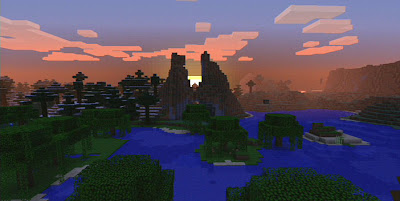
[TOP] A shot of the new sunset as the sun goes down between a double spire in the middle of the map. I'm not a fan of the sunsets -- they look horrible when viewed at the edge of the map -- but this one looks alright I guess.

[ABOVE] This is an overhang and a land bridge -- both medium in size -- in the mountainous region of the map. As you can see, these mountains aren't all that impressive, but I thought this was a good shot.

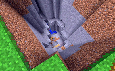
[ABOVE] - This is a dead drop that lands on top of a stronghold. The stronghold is alright, but getting down to it is an epic challenge. You can find this entrance at 132.64.-323.
No comments:
Post a Comment